Data is king—with more data you can make better decisions. Keeping subcontractors, management, investors, insurance companies, marketing department-you name it-keeping all on the same page is a difficult task. Sula Aerial offers solutions and systems that will solve just that. We deliver through a secure cloud-based solution so your team can leverage the data to solve problems through all levels.
Construction Video Services
Below is a list of solutions that will keep your team on track, save you money, and keep your team safe.
- Maximize site data by collaborating with everyone involved on your project
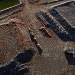
- Aerial Mapping (Similar to Google Maps but higher resolution and up to date)
- 3D models of your site for BIM workflow
- Linear, area and volume measurements
- Tracking & manage equipment
- Site planning and progress tracking
- Aerial inspection
- Create captivating video and photo marketing deliverables
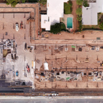
These are very high-resolution maps we create to give you the most up to date information of your jobsite.
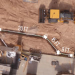
Simply being able to measure your site helps prevent and solves problems which saves you time, rework and money.
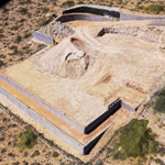
Inspect your site from anywhere. We create a 3D Textured Models of your site so your specialist can inspect your site from anywhere.
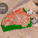
Need to check material inventory, balance a site or fill a hole? We’ve got you covered.
Site Progress
We create 2D and 3D maps of your site to document site progress. Great for keeping everyone involved on the same page.
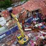
With multiple applications, video and photo give you the flexibility to inspect, create marketing material, and more!